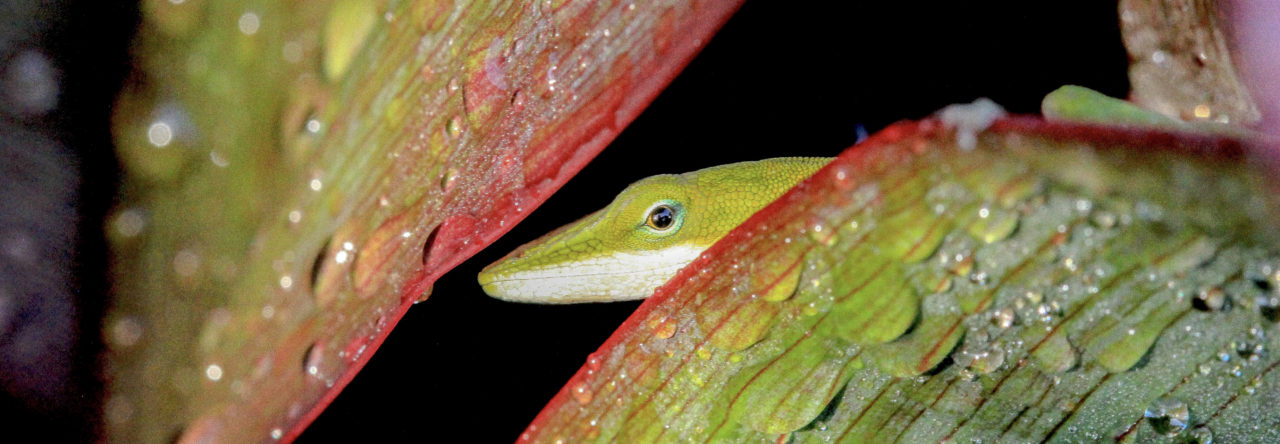
Adult water anole (Anolis aquaticus) from Coto Brus, Costa Rica, with an exhaled – and recycled – air bubble. Photo by Lindsey Swierk.
Over the past few years, I’ve been accumulating evidence that the water anole (Anolis aquaticus) might be a tiny scuba diver in the streams of its home in southern Costa Rica. Anolis aquaticus takes to the water as refuge from predators, swimming and often diving underwater for long periods of time – the record at my study site is currently 16 minutes! To enable these crazy-long dives, it’s possible that anoles may have come up with a scuba-tank method of sorts to “breathe” underwater. I’ve compiled a video of what appears to be underwater respiration of a recycled air bubble that clings to the anole’s head. (A few more details about these observations will be in the upcoming March issue of Herpetological Review.) For now, enjoy the video!
César Barrio (Doc Frog to those of you who know him on Facebook or through his photography) recently posted this:
Here’s more information from César:
“Well, It is not completely sure it is eewi. Anolis eewi was described from Toronó, part of Chimantá tepuy, the neighbor tepuy of Auyan, where this one was found. This individual was at the same altitude (around 2000 m) and conditions as eewi. Norops planiceps is a widespread species in northern South America, and is very variable, but the proportions and the general feeling of my nose as a taxonomist told me this was different. Probably the best way to present it is as cf. eewi, even now eewi is synonym of planiceps.”
The last sentence reminds me to point out that eewi was named after Ernest E. Williams, who was often known by his initials, EEW. Williams then wrote a paper that sunk the species into what was, at that time, A. chrysolepis (if I recall correctly). While searching for the Williams paper, I came across another paper published by Williams in Breviora in 1996 reporting specimens of A. chrysolepis eewi obsercved (collected?) in the Venezuelan tepuis.
My name is Anthony Gilbert, and I’ll be coordinating the upcoming Anole blog posts for the Society of Integrative and Comparative Biology conference this 3-8 January in sunny Tampa, Florida. We have over 30 different talks and posters presented by students, postdocs and faculty at this conference this year and we are looking for some additional volunteers to help us get these posts up!
If you’re going to be in Tampa, and you want to help the Annals out, send me an email at anthony.gilbert09@gmail.com. We welcome folks who both have and have not blogged for the Annals in the past.
If you’d like to help us out, contact me and I’ll forward you a spreadsheet a few days before the conference so you can slot yourself in for whichever presentations you’d like to cover. I can also send you instructions on how to write up a post if you would like!
Check out the Anole Annals twitter account (@AnoleAnnals) with the #SICB2019 hashtag during the conference for updates on talks, posters, and other conference-related events. It is supposed to be sunny in Florida this year, so the anoles themselves might be out in force along with all of the conference attendees!
Last year, just days after my team and I finished surveying two populations of Anolis scriptus in Turks and Caicos, the islands took a direct hit from Hurricane Irma. Shortly after that, Hurricane Maria barreled through. We realized that we had a serendipitous opportunity to investigate natural selection, and so Anthony Herrel and I returned to the islands, measured the survivors and, well, you’ll just have to keep scrolling…
I recently heard about ESRI StoryMaps for the first time. They’re a great, free online platform for using maps, pictures, and videos to tell a compelling story. I think they make for a great science communication tool. I put together a StoryMap about our project in Turks and Caicos and thought I’d share it here. I’d definitely recommend anyone interested to take a shot at making one, too. (Click here if the embed doesn’t work for you – it’s prettier full screen anyway).
Microbiome studies focused on ecologically relevant vertebrate models like reptiles have been limited. Because of their relatively small home range, fast maturation, and high fecundity, lizards are an excellent reptilian terrestrial indicator species. For this study we used the green anole, Anolis carolinensis, to assess the impact of military relevant contaminants on fecal microbiome composition. Fourteen day sub-acute exposures were conducted via oral gavage with 2,4,6-Trinitrotoluene (TNT) and inorganic lead at doses of 60 mg/kg and 20 mg/kg of body weight, respectively. Body weights and food consumption were monitored and fecal samples were collected for high-throughput 16S rRNA gene amplicon sequencing and analytical chemistry at days 0 and 15. At the end of the study, liver and gut were harvested for body burden data. Chemical analysis confirmed accumulation of TNT, TNT transformation products, and lead in liver tissue and fecal samples. Bacterial community analysis of fecal material revealed significant differences between day 0 and day 15 of TNT exposed anoles with an operational taxonomic unit (OTU) within the genus Erwinia representing 32% of the microbial community in TNT exposed anoles. Predictable changes in gut microbiome composition could offer an easily assayed, noninvasive biomarker for specific chemical exposure providing enhanced scientific support to risk assessments on military installations.
Satellite imagery of when the lights went out in the brightest region of the Caribbean.
You have probably heard about the hurricane’s effect on humans: months of ensuing darkness, destroyed roads, houses leveled and roofs torn clean off, no fresh water, and significantly crippled infrastructure and public services leading to over 1,000 lives lost when it all was over.
I’ve been back to the island now twice since the hurricane, once in January of 2018 and once last week (November 2018).
Four months post-hurricane
The destruction to both urban and forest areas was jaw-dropping when I visited in January to help Kevin Aviles-Rodriguez (UMass Boston) launch a project on urban lizard recovery and natural selection following hurricanes. (Side note – this research has yielded some really intriguing results so far and I look forward to Kevin sharing those with us here at Anole Annals in the future!) On that trip, four months after the hurricane, I found the island in disrepair. Many people still had no power or clean water, stoplights and electrical lines dangled from their snapped poles island-wide, roofs were covered in blue tarps, and driving involved dodging car-eating potholes, downed power lines, and debris. Most stores and restaurants were closed and many roads were impassable.
A stand of trees on the west coast four months post-hurricane (near Rincón).
The trees left standing in urban areas were bare toothpicks. I’m told that immediately following the hurricane, the leaves looked like green snow coating the ground several inches thick. Most of the trees that survived were the large and common urban species: mango, flamboyán, ceiba–leafless but still rooted. When we visited the forests I was equally shocked by the destruction: trees looked as if someone clipped them all off clean around 15 feet up, the canopy was gone and all of the large trees like Cecropia and Cocoloba were downed. Lianas had taken over giving the forests a bushy, surreal appearance. I left the island that January wondering how long it would take to recover; the human side and nature side alike had a long road ahead of them.
What was once closed-canopy secondary forest on the north coast (near Arecibo).
Fourteen months post-hurricane
When I returned last week, now 14 months post-hurricane, I was pleasantly surprised to see the island was recovering. Roads had been repaired, power had been restored, stoplights were working, debris had been cleared, restaurants and stores were open, and houses rebuilt. From the human side of things, the island seemed to be recovering. On the west side of the island, the leaves of the large trees had returned. Forested areas had more dense understory than typical and the canopy was still fairly open, but overall it seemed like the forests and urban areas were both returning to normalcy. I found many urban lizards without a problem, including Anolis cristatellus, A. pulchellus, A. stratulus, Ameiva exsul and the non-native green iguana. I was surprised however, that the nights were eerily quiet. The familiar ear piercing chorus of coqui was reduced to intermittent calls of only a few individuals. The coqui don’t seem to have recovered quite as well as the anoles.
No trees? This urban A. cristatellus seems okay with that.
Anolis cristatellus
Anolis pulchellus
Many challenges certainly still face the residents of the island, but it was starting to look more like the Puerto Rico I knew. So it was quite a shock when I visited the newly re-opened El Yunque National Park. El Yunque was hit particularly hard by the hurricane as the first landfall was just south of the forest near Yabucoa. Strong bands of wind pummeled the area, leading to massive landslides that closed the rainforest for months. The national park website said that only La Coca falls and Yokahu Tower were open to visitors, but I found a park ranger who informed me that the Mt. Britton trail was open (and the road to the peak of El Yunque had been cleared as well, though not the cloud forest trail).
As I drove up the mountainside to the Mt. Britton trailhead I was shocked at how open the forest was. When we arrived at the trailhead, my jaw dropped. The canopy had not recovered at all. The palms seemed to be the only trees that survived. I’ve hiked this trail many times, but this was the first time I did not wear a long-sleeve shirt – it was hot and dry. Perhaps the lack of animals shouldn’t have come as a surprise then. I didn’t hear a single coqui call while hiking the trail, where in the past we would hear many different species along the route. I also did not see a single Anolis gundlachi, where before my favorite trick was to tell someone that I could make lizards appear on demand then reach out and snatch one off a tree – they were that common! I did see a handful of Anolis evermanni, but only a few. Below are a couple of before and after photos of the same portions of the trail.
Mt. Britton trail in January 2017
Mt. Britton trail now, 14 months post hurricane
The entrance to the Mt. Britton trail before the hurricane…
and the same location 14 months after the hurricane
The impacts of hurricanes on wildlife
Recent research has shown that the insect populations of El Yunque have been declining for years, and certainly hurricane Maria did not help this situation. Perhaps the anole and coqui populations have suffered because of a collapse of food resources? Or perhaps the microclimatic shifts were too much for the lizards to handle? Anolis gundlachi does have a strong affinity for cool and moist habitats and it seems quite likely that with the current state of El Yunque, very little suitable climatic habitat exists for this species. Or perhaps the hurricane itself reduced the anole populations. Recent research on Anolis scriptus found that hurricanes can pose strong selective pressures leading to phenotypic change. Whatever the reason for the apparent decline, I am eager to check back in with the lizards in a few months when I visit again and even more eager to hear about the research of those studying herpetofaunal hurricane recovery.
No A. gundlachi to be found at El Yunque 14 months after the hurricane, but quite a few A. evermanni like the one seen here.
Are you studying the effects of hurricanes on lizards? Are you studying the recovery of Puerto Rican herpetofauna after Maria? We would love to hear more about it! Let us know in the comments, or consider contributing a blog post to Anole Annals.
The little known and very rare Anolis darlingtoni, endemic to Haiti and likely to disappear. Photo by Miguel Landestoy from Haiti National Trust website
Analysis of satellite imagery and aerial photographs indicate that all of Haiti’s remaining primary forest will disappear in less than two decades if current deforestation rates continue. Results indicate primary forest cover in Haiti shrank from 4.4 percent in 1988 to just 0.32 percent in 2016, and that 42 of Haiti’s 50 largest mountains have lost all of their primary forest cover.
These forests are home to endangered animals found nowhere else in the world; researchers say the country is already experiencing a mass extinction event due to habitat loss.
Deforestation-intensified flooding has also been implicated in thousands of human deaths.
Researchers say Haiti’s forest loss is driven largely by charcoal production and agriculture.
New findings indicate that at current deforestation rates, all of Haiti’s primary forest will be gone within the next two decades, leading to the loss of most of the country’s endemic species.
The study was authored by researchers at Temple University, Oregon State University, the U.S. Forest Service and Société Audubon Haiti, a non-profit conservation organization based in Haiti. Its results were published recently in Proceedings of the National Academy of Sciences.
By analyzing aerial photography and satellite images, researchers discovered that primary forest cover in Haiti shrank from 4.4 percent in 1988 to just 0.32 percent in 2016. They report that 42 of Haiti’s 50 largest mountains have lost all of their primary forests and the country is already undergoing a mass extinction of its wildlife due to habitat loss.
“Haiti’s recognized as having the highest proportion of threatened amphibians in the world,” said S. Blair Hedges, director of Temple University’s Center for Biodiversity and lead author of the study, in an interview with Mongabay. “And that’s largely from the deforestation.”
Other species at risk include the Hispaniolan solenodon (Solenodon paradoxus), a large shrew-like animal native to Haiti and neighboring Dominican Republic. One of the oldest mammals on the planet, the solenodon survived the mass extinction event that wiped out the dinosaurs.
But it’s not faring well in today’s world.
“It’s almost extinct,” Hedges said. “It’s very, very hard to find.” However, the team did see recent evidence of one in mountainous primary forest during a biodiversity survey that took place between 2009 and 2015.
In all, the survey turned up 28 species that are endemic to specific mountaintops – including several new frog species. Hedges says there were likely many more, but as their habitat disappeared, so did they.
“Unfortunately entire mountains have been deforested before biologists have surveyed them, so there were almost certainly many more species that we will never know about,” Hedges said.
Along with the extinctions of unique animals found nowhere else, Haiti’s deforestation has another consequence: landslides and flooding. The researchers found that without tree roots to hold soil, mountains tended to lose their topsoil to erosion soon after deforestation. And without trees to sop up rainwater, lowland areas are much more prone to catastrophic floods.
“Hundreds to thousands of Haitians die each year from flooding that is largely deforestation-related,” Hedges said. He pointed to a flooding event in 2004 that killed more than 1,200 people in a single town.
Hedges says that Haiti’s deforestation is largely driven by small-scale farming and charcoal production, which involves harvesting wood and heating it to remove water and volatile compounds. Doing this turns wood into a source of fuel that can be burned without producing as much smoke.
Around 11 million people live in Haiti, and many of them depend on wood charcoal for fuel and subsistence farming for food. As the lowlands lost their trees, people began deforesting higher and higher into the mountains.
The researchers witnessed this first-hand while conducting their biodiversity surveys, even encountering locals at study sites they had to use a helicopter to reach.
“I did a lot of hiking and we would run into Haitians at the most remote places in the country,” Hedges said.
Even protected areas aren’t immune from deforestation. Hedges recalled meeting a ranger a few years ago in Pic Macaya National Park – one of the last remaining sites of primary forest in Haiti.
“He told us that there were only 20 of them [rangers] but at any given time there are at least 200 teams of tree cutters all throughout the park – it’s a really big area – and they all have weapons, yet the rangers don’t have any weapons.”
In their study, Hedges and his colleagues write that Haiti’s two original national parks, Pic Macaya and La Visite, lost between 60 and 75 percent of their primary forest cover since they were declared protected areas 35 years ago. The researchers say improved monitoring is needed if forests – particularly primary forests – can be saved.
“Expanded detection and monitoring of primary forest globally will improve the efficiency of conservation measures, inside and outside of protected areas,” the authors write.
Monitoring forests starts with figuring out what really counts as forest, which can be surprisingly contentious. The Food and Agriculture Organization of the United Nations (FAO), for instance, defines forest as “Land spanning more than 0.5 hectares with trees higher than 5 meters and a canopy cover of more than 10 percent.”
However, according to Hedges, such a generous definition can distort the reality of a country’s forest cover and overlook primary forests, which are vital for biodiversity.
“When [the FAO defines] forests as having up to 90 percent of the trees missing, many of us would not call that forest, “ Hedges said, adding, “for a biologist like myself it’s almost absurd really.”
The FAO doesn’t plan on changing its approach to forest definition, according to Anssi Pekkarinen, team leader of the FAO’s Global Forest Resources Assessment. However, he says they are allowing “more detailed reporting at the sub-category level,” which includes differentiation of “planted forest” and “naturally regenerating“ forest.
“FAO is also working together with its partners to further improve the consistency of the reporting on primary forest,” Pekkarinen told Mongabay. “This work was initiated in 2017 and is expected to be completed within the coming years.”
In response to the country’s deforestation crisis, reforestation projects have popped up, including Haiti Takes Root and the USAID Reforestation Project launched in January 2018, which aims to plant more than five million trees.
While reforestation can have positive outcomes, Hedges and his colleagues say that preservation of primary forest is the best way to stymie extinction.
“Primary forest is critical for maintaining much of the world’s biodiversity, and its loss is the greatest threat to species survival, even if primary forest is later replaced by secondary growth,” they write.
The researchers note that even places where some primary forest is left standing quickly become un-forested due to degradation. “However, lightly disturbed habitats could provide lifelines for some species if protected and allowed to recover.”
To help Haiti hold on to its forests and biodiversity, Hedges started an NGO called the Haiti National Trust that is set to purchase a mountain in Haiti in a bid to preserve its remaining primary forest.
“Our mission is to protect the last primary forests and biodiversity hot spots,” Hedges said. “It is a big task and will require a large inflow of resources, but I remain optimistic.”
Citation: Hedges, S. B., Cohen, W. B., Timyan, J., & Yang, Z. (2018). Haiti’s biodiversity threatened by nearly complete loss of primary forest. Proceedings of the National Academy of Sciences, 201809753.